Remote Sensing to the Rescue

Clapp decided to enlist NASA's help because of its expertise in applying remote sensing. He contacted Dr. Ronald Blom of NASA's Jet Propulsion Laboratory for help. Data from an experiment on the NASA space shuttle using imaging radar was of particular interest. This experiment bounced radar off the Earth's surface to determine the type of terrain. Since the radar penetrated through dry sand, they thought the remains of a buried fortress might be revealed.
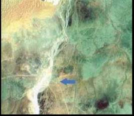
The initial radar images yielded no direct indication of the location of the site, but images from the Landsat and SPOT remote sensing satellites showed distinct tracks through the desert. The researchers identified these tracks as old caravan routes. The caravan routes converged at a place called Ash Shisr, near the eastern edge of the Empty Quarter.

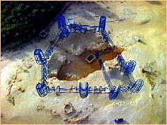
Two expeditions to Oman were mounted; one in 1990 and one in 1991. The expedition team included Nicholas Clapp, Dr. Ronald Blom, archaeologist Dr. Juris Zarins, and British explorer Sir Ranulph Fiennes, who had been on previous Ubar searches. The team investigated the area around Ash Shisr, and soon an archaeological excavation began.
الصفحة الأصلية
http://observe.arc.nasa.gov/nasa/exh...ar/ubar_3.html


 هو آخر الرسل للإنس والجــن ؟؟
تعليق